If you enjoy hiking and want to do it in an unusual location, book your trip to Lampedusa in autumn. That’s right, the island famous for its beaches and warm, almost tropical climate, changes its appearance in the colder seasons. The first rains don’t alter the average temperature, which always stays around 20-25 degrees Celsius. However, rain allows the countryside to blossom again in a celebration of greenery and flowers. These are the perfect seasons for a stroll in the heart of the island… places you’d perhaps never go in summer!
Lampedusa: how to get there?
Lampedusa has its own small airport (LMP), which in the summer enjoys numerous connections to/from the main Sicilian and Italian airports. If you prefer, you can always land at Palermo Airport (PMO) or Fontanarossa Catania (CTA) and then reach Agrigento with a rental car. From here, you can board a ferry to Lampedusa and get there in about eight hours. On the island, you can rely on our transfers to cover the short distances between points.
Hiking in the Heart of Lampedusa
This inland trek may not be the most spectacular, but by walking these few kilometers diagonally inland (from the center of Lampedusa to the Stone Circle, passing through the Cava di Beddu), in less than an hour’s walk, you’ll admire hidden corners of the famous island. You will see the locals’ gardens and fields, glimpses of greenery that usually don’t exist in summer. The Cava di Beddu—an ancient abandoned stone quarry transformed into a theater-memorial for the victims of shipwrecks—is a monument where you can pause to reflect on the meaning of life. Meanwhile, the mysterious Stone Circle, a large example out of many others scattered across the island (called “Timpùna”), will pique your curiosity and imagination. Returning along the Ponente street, you can admire the dammusi, typical Sicilian country houses, often restored and converted into hotels.
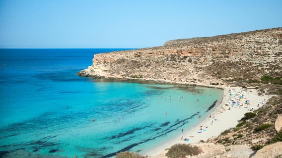
Trek to the highest point
Another interesting trek to do in Lampedusa in autumn is the one that starts from the famous Isola dei Conigli beach, offering breathtaking views of a fairytale sea even in winter. Moving northwest, through the Lampedusa Nature Reserve, you reach a place with a dreamy name: Monte Albero del Sole (mount Sun Tree).
But this is not a real “mountain”, it’s little more than a hill instead: its maximum height is 133 meters above sea level. Yet, being the highest point on Lampedusa, it offers a decent view of the island’s landscape from above. The mountain houses a small altar with a crucifix, which the locals affectionately call “u Signuruzzu” (Little Lord).
Towards Capo Grecale…
A charming short walk could also be the one that leads from the center of Lampedusa to its eastern tip: Capo Grecale.
Starting from the town, you follow the road of the same name, Via Grecale, heading towards the bay known as Mare Morto (Dead Sea). A name that couldn’t have been more inappropriate, given the breathtaking beauty of that sea and beach! When you reach Capo Grecale, you can admire the contrast between the blue of the sea and the dazzling white of the cliffs. The whole place is dominated by an ancient lighthouse: 19 meters high and a long-standing landmark for fishermen, this tower is also a symbol for romantics who can admire the sunrise from here.
Archaeological Lampedusa
Ancient history enthusiasts can follow an interesting itinerary that covers the island’s archaeological beauties.
Starting from the excavations on Via Roma, in the historic part of the town, you move towards the sea and the ruins of Cala Palma—a series of caves and underground corridors that connect the port to the heart of the town. Not far from these sites are the Roman pools of Cala Salina: these tanks, used for fish farming and for the production of certain food products, remained in use until recently.
This tour can be completed in less than 15 minutes, given the proximity of the sites. Walking a little further out of town, you can discover other “mysterious” stone circles between Cala Grecale and Punta Alaimo.

